Hurricane season is here as of June 1st and will last the next six months, ending November 30th, with the peak season beginning about mid-August and lasting until the end of October. This year, the National Oceanic and Atmospheric Administration (NOAA) predicts an above-average hurricane season, which is bound to make our first year exciting! Most of the states I lived in had some weather issues or seismic activity. California of course has its earthquakes and Santa Anna winds. Virginia had its hurricane season, which is the same as Florida, but honestly, the most I ever experienced was a “watch”. Washington didn’t have anything to worry about and Colorado had its tornados and major snowstorms here and there. My husband had the joy of living in Oklahoma with even more tornados, so this isn’t anything surprising to either of us.
ALL THINGS HURRICANE
HURRICANE ORIGIN AND DEFINITION

The name hurricane comes from the Mayan word Hunraqan (Hurakan), meaning “one-legged” and was known as U K’ux Kaj or the “Heart of Sky” and is the god of wind, storms, and fire. U K’ux Kaj was one of the major creator deities that were involved in creating humanity and the cause of the great flood. If you want to read more about Huracan, you can find more information here.
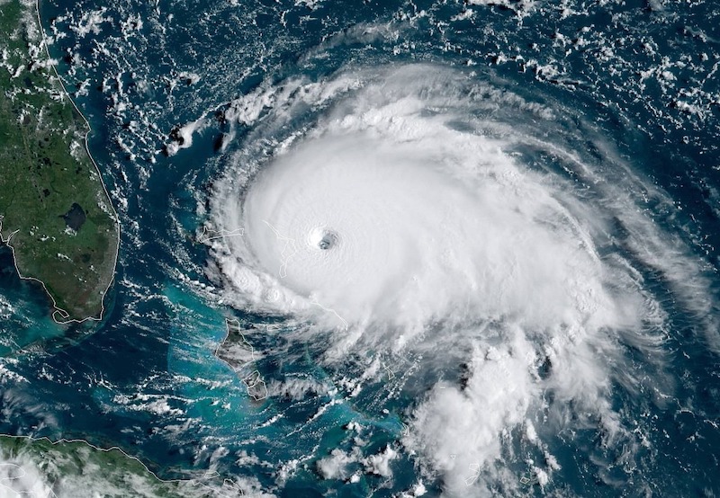
Hurricanes as we know them are tropical storms that have violent winds that reach a consistent speed of 74 miles per hour or more. They can last two weeks or more when over open water and can run a path along the entire eastern seaboard. They can be 20 to 1000 miles wide according to NASA and can be severely dangerous with storms that include torrential rains, high winds, and severe storm surges.
The record size was a tropical storm in the Philippines called Typhoon Tip in 1979, which was 1380 miles wide and the winds extended 690 miles from the center. The smallest was Tropical Storm Marco in Mexico in 2008, which was only about 10 miles wide but the winds extended to 11.5 miles from the center.
You may have heard the term cyclone and aren’t sure what the difference is between that and a hurricane and it is simply the hemisphere you find them as to what they are called. Hurricanes form in the northern hemisphere, and due to the Coriolis effect, they rotate counterclockwise and cyclones form in the southern hemisphere, or south of the equator, rotate clockwise. Other than that, they are the same storm.
There are certain conditions that must be met in order to be considered a hurricane.
- Low-pressure system
- Warm temperatures over the ocean
- Moist environment
- Tropical wind patterns over the equator
WHAT’S IN THE NAME OF A HURRICANE?

Ever wonder where they get the names for hurricanes? Starting in 1953, hurricanes started getting female names. It is believed that the reason for the female names is that it was a maritime tradition because the ocean is traditionally referred to as a woman and pretty much anything sea-related. As of 1978 and 1979, however, male names have been added to both the Pacific and Atlantic storm lists alternating one after the other. For example, this year we start with Alex (M), Bonnie (F), and then Colin (M). This will continue through the entire list, ending with Walter.
The Atlantic lists are repeated every six years. The only time a name is not repeated is if the previously named storm was deadly and it would be considered insensitive to name another storm that same name. An example would be Hurricane Andrew (1992) and Katrina (2005). A list of retired names can be found here. For a list of names for the next six years, you can find them here at the National Hurricane Center and Central Pacific Hurricane Center.
There are only 21 letters used for naming tropical storms, with the letters Q, U, X, Y, and Z being omitted, so, unfortunately, there will never be a storm named Quint, Ulysses, Xavier, Yolanda, or Zeus. Seriously, no Quint? He just has tropical storm written all over him.
HOW HURRICANES FORM
Hurricanes are tropical storms that start in the warm waters found near the equator and form only in the tropical region where the water is at least 80 degrees Fahrenheit. As the warm waters evaporate, creating warm moist air which rises and is met with cooler wind pockets that come across the Atlantic ocean from other areas, like Africa, causing unstable air temperatures. The cooler air pushes the warm air down, becoming warm itself, and then rises to meet cooler air. This circular pattern will continue until clouds are formed. As more air rises, the winds continue in a circular pattern, gathering more storm clouds. Once the winds reach a continuous speed of 74 mph or greater, it officially becomes a hurricane. There are other key ingredients that must be met such as moisture at about 15000 ft and weak wind speeds within the column in order for the clouds to not break apart. Now, once a hurricane hits land, it will weaken because it needs to be fueled by the moisture from the water that comes from the ocean, but it can still create a lot of damage before it breaks apart.
THE STRUCTURE OF A TROPICAL STORM
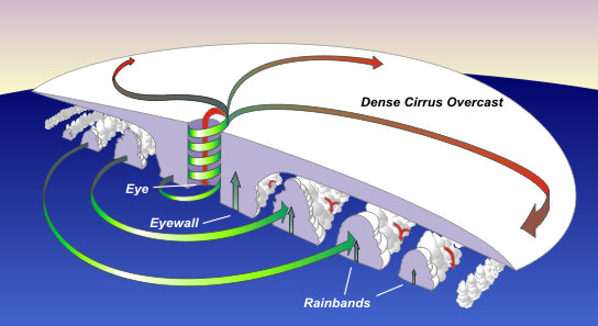
There are five parts to a hurricane. They are the outflow, feeder bands, eyewall, the eye, and the storm surge.
THE OUTFLOW or DENSE CIRRUS OVERCAST is the high-level clouds moving outward from the hurricane. You know, all the white puffy clouds you see when the meteorologist shows you how the storm looks from outer space on their screen.
THE FEEDER BANDS or RAIN BANDS are the areas of heavy rain and gusty winds that are fed by the warm ocean. These bands get more pronounced as the storm intensifies. You can also find that tornadoes can form within these bands. As you see in the image above, the bands increase in size as they get closer to the eye.
THE EYEWALL forms around the EYE of the hurricane. It is often viewed as the most dangerous part of the hurricane and the one place you don’t want to be. It consists of a ring of tall thunderstorms and heavy rains, along with the strongest winds. If the eye structure changes, the wind speeds can be affected and are telling of the intensity of the storm. As the eye grows or shrinks, the eyewall itself can become two walls.
THE EYE is the center of a hurricane. This area is relatively calm and clear. The eye is absent of sinking air and produces lighter winds that don’t exceed 15 mph. It can be 20-40 miles wide, so if you are in the middle of it, don’t assume the storm has passed. Though it isn’t fully understood as to why an eye actually forms, there are theories related to centrifugal force and momentum. They do tend to develop when the sustained winds exceed the minimum 74 mph, which as you know, is the transitional speed from a tropical storm to a hurricane. Since it is the calmest section of the storm, the phrase “In the Eye of the Storm” is often used to describe the center of a disagreement or controversial situation or when things calm down just enough to give the feeling that things have settled, but the storm is far from over. A period of peace.
THE STORM SURGE is the rising of the sea levels due to atmospheric pressure changes and winds caused by a storm. This is also referred to as a wall of water. Here in Florida, we have a natural wall that can help with lessening the intensity of storm surges and helps to protect our coastlines. If you aren’t familiar with these natural ramparts, you can read about them in my blog about Mangroves, here.
HOW HURRICANES ARE CLASSIFIED

TROPICAL DEPRESSIONS are is when the hurricane/cyclone reaches the sustained surface wind of 38 mph or less for a maximum of one minute.
TROPICAL STORMS are when the hurricane/cyclone reaches a sustained wind of 39 to 73 mph for a maximum of one minute.
HURRICANES are when the TROPICAL STORM reaches the surface wind speeds of 74 mph or more for a maximum of one minute. Categories 1 and 2
MAJOR HURRICANES are when a HURRICANE reaches speeds of 110 mph or more, making it a Category 3.
When you hear that a hurricane has reached a certain category, you can thank Herb Saffir, a wind engineer, and Bob Simpson, a meteorologist for coming up with The Saffir-Simpson Hurricane Scale. This scale is used to categorize hurricanes based on their wind velocity, central pressure, and height of the storm surge. As you can see, wind speed and storm surge levels are important to keep an eye on, especially in coastal areas. The closest hurricane to where I currently live was Hurricane Charlie in 2004, which was a Category 4.
HURRICANE DANGERS
Some of the major things you need to worry about with hurricanes are storm surges, heavy rains, flooding, high winds, rip currents, which can be dangerous even if the hurricane is 1000 miles offshore, and possible tornadoes both at sea and on land. Keep in mind that storm surges can reach 20 feet in height and cover hundreds of coastal miles. It is extremely important that you remain mindful during hurricane season if you are active on the water, especially if you spend time offshore. Aside from the loss of life, bridges, roads, and other structures can be damaged several miles inland and within estuaries, saltwater intrusion endangers public health and the environment.
HOW TO PREPARE FOR A HURRICANE IN FLORIDA
There are several things you can do to prepare for hurricane season and the Florida Department of Emergency Management has created an interactive website to help you design lists that support your own home or business needs. Both have valuable links and if you are creative in your search, you can locate emergency evacuation plans, but the link on the family page isn’t working properly.


Know your city’s evacuation zone. You will find signs all around town identifying evacuation zones. They are labeled from Tropical Storm Zone, then Zone A (and AB) through F, and then Zone L. Zone A is the most vulnerable and Zone F is the safest.
Once you know your zone, make sure you stay informed. You can sign up for emergency notifications through several weather apps. I get notifications through my Alexa App and the National Weather Services.
Plan your evacuation. What routes would you take and from which location? Where will you go? Do you have emergency items in your car at all times? Do you have extra fuel? Keep in mind that gasoline has a shelf life of 3 to 6 mos, while diesel will begin to break down at about a year. Try your best to always keep your tank half full during hurricane season just to be safe. Do you have a Go-Bag? Do you have a household master folder with important docs and copies of IDs and registrations? Do you have emergency supplies for your home in case you are in a safe zone but you lose power or water access? Is your home properly prepared to take on a storm? Make a decision your family can agree upon as to whether or not you will stay or go and when that decision will change? For now, we have had a Go-Bag ready since we lived in Colorado, due to tornadoes, but we definitely need to update everything now that we are in a new state, with new issues. Good thing we have vehicles that can move through the water more easily than a low-sitting car. Don’t worry if you don’t know about Go-Bags or Household Master Folders, I will be doing blogs on those in the near future as well, in the meantime, you can find tons of ideas on Pinterest board.
On a side note, it is a good idea to consider where you purchase a home and whether or not your potential home is within a flood zone and how it will affect your homeowner’s insurance.

HOLD ON TIGHT
I always tell my students it’s important to know what to expect and that the knowledge you gain can help prepare you for anything that may come your way and hopefully, in the end, it never comes. And anyone who has that girl scout/boy scout/military mind knows that being prepared helps to reduce the stress and anxiety that comes during emergency situations as a prepared mind tends to handle things more clearly and with confidence.
If you would like to learn more about weather patterns, I am currently in the middle of a meteorology course with Centre of Excellence in the UK, which I started before I moved here, because, let’s face it, Hurricane Season!!! Keep an EYE out for discounts for their courses as they can be pricey.
Stay Salty and Stay Connected
Kelley
RESOURCES
- Florida Disaster – Family Plan
- Florida Disaster – Business Plan
- Florida Disaster – Know Your Zone
- Florida Climate Center
- NHC NOAA Saffir-Simpson Scale
- READY.Gov
- Hurricanes for Kids
- Hurricanes, Earthquakes, Volcanoes, Tsunamis, and more. For Kids
291 total views, 1 views today
2 thoughts on “Hurricane Season – Know More About the Storms We Face”